Land use
Changing maps raise questions about the future

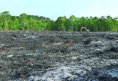
Heavy equipment started work this spring clearing 8.8 acres at the corner of Martin Luther King Road and Petigru Drive for a 22-lot subdivision.
Seen from the street, it’s an example of the growth that many residents feel is overwhelming the community.
Seen from the proposed maps that show how the area will grow in the future, it’s a sign of growth yet to come.
A draft of Georgetown County’s future land use maps proposes changing the designation of that tract and a handful of adjacent lots from “medium density residential” to “village center.”
The current designation indicates the area is suitable for 2.1 to 5 dwellings an acre. The development under way by the national homebuilder Toll Brothers will have 3.9 units an acre.
As a village center, a designation that is new to the current revision of the land use element of Georgetown County’s comprehensive plan, the property would be suited to a combination of retail, restaurant or services uses along with residential. That would be around six to 10 units an acre.
The parcel is one of several that stand out on a map prepared by the citizens group Keep It Green that shows how the proposed land use maps promote increased residential density above what is contained in the current maps.
“There are some head-scratchers like that one,” said Cindy Person, chief counsel for Keep It Green Advocacy.
Holly Richardson, the county planning director, said she was also puzzled by the change, which was proposed by consultants hired last year to update the land use plan.
“It’s funny that you picked that as an example,” she said.
It’s one of several that she asked the consultants to change before the maps come up for another review by the Planning Commission next week.
Tonight at 6, Keep It Green is holding its own forum on the maps at the Waccamaw Library. It had someone versed in geographic information systems overlay the proposed land uses on the current uses.
“It’s a pretty significant increase” in the number of dwellings that could be allowed, said Person, who declined to give an actual number in advance of the meeting. “It doesn’t mean that it will happen. The fact that it could happen is scary enough.”
State law requires local governments to update their comprehensive plans every 10 years. The current land use element, one of 10 that the law requires, was adopted in 2007 and reviewed in 2015. The maps are a part of that element and are the foundation of the county zoning ordinance.
Four lawsuits brought by Keep It Green, neighbors and other groups – represented by Person – have challenged Georgetown County land use approvals by arguing, in part, that the county failed to comply with state law that says “regulations must be made in accordance with the comprehensive plan.”
The county argues that the purpose of the comprehensive plan elements is, as the law states, “to guide the development and redevelopment of its area.” Three of the suits were dismissed in Circuit Court and are now on appeal. The property owner in the other suit has appealed a lower court ruling against his effort to be dropped as a party.
The tract at Petigru and Martin Luther King shows how the land use maps figure in the process. Even though designated medium density, the zoning on the property was “residential half-acre.” That would allow no more than two units an acre, which the county classifies as low density. (Anything from 5.1 to 16 units an acre is considered high density.)
The former owners, Guerry Green and David Gundling, asked the county to rezone the property for 26 lots, keeping within the medium density limit at 4.6 units an acre, but adding nine more lots than the half-acre zoning allowed. They argued that developing the tract with half-acre lots would require each of the 17 lots to have a driveway on Petigru Drive.
As a “flexible design district,” the development would have smaller lots served by an internal street. The smaller lots would also provide more common space for buffers and stormwater retention.
Keep It Green initially opposed the zoning change, but withdrew that opposition when the owners agreed to reduce the number of units it would build and place a conservation easement on a nearby tract that is part of the River Club “planned development.” Five lots were also cut from the proposal for the 8.8 acres.
As a flex district with a unique set of zoning rules, the tract should probably be shown as a “covenant community” in the future land use maps, Richardson said. That is a new designation that is applied to all planned developments.
It’s likely that the consultants saw the tract, undisturbed when they started work last year, as suitable to a mix of homes and services because of its location at an intersection of secondary roads, she said.
“They also did a suitability alalysis,” Richardson said. “They looked with a wider lens that just what is the existing zoning.”
Changing the land use maps, she noted, doesn’t change what can be done with the property, she noted. That is done through the zoning ordinance.
But Person pointed out that argument cuts both ways. The land use plan calls for reducing the top density in “general residential” districts from 16 to 12 units an acre.
“Downzoning is part of the comprehensive plan,” she said. “Don’t pretend that it is reducing GR zoning.”
That has to be done by changing the zoning ordinance.
Since the current plan was adopted, the county has changed the zoning to reduce the number of dwellings allowed on some parcels, Richardson said, but she added that was done with the approval of the property owners.
“We do have language in this document for the first time that talks about targeted rezoning,” she said. “It’s not a switch that you flip. It’s a policy decision that County Council is going to have to make at the end of the day.
The proposal for the Petigru tract is troubling in another way, Person said.
“This is being done on a map by planners who don’t understand the area,” she said. “They’re not doing what citizens have made very clear they want.”
And that is reducing the number of future dwellings on Waccamaw Neck.
The Planning Commission will take up the land use element March 16 at 5:30 p.m. in the Howard Center in Georgetown.


