Land use
Consultants connect the dots after input on comp plan
Consultants working to complete an update to the long-overdue land use element of Georgetown County comprehensive plan came away from a series of meetings last month with a clear understanding of the county’s diverse community.
“It’s very stark,” said Jake Petrosky, a community planner with Stewart, a North Carolina design firm with offices in Columbia. “There’s something that’s shared between them: environmental constraints.”
Analysis of comments collected at three community forums confirmed the county’s own findings in a 2021 survey that natural resource preservation is a top concern. But while the county halted work on the land use plan a year before it launched the survey, the consultants hired this spring for $105,700 are due to deliver a draft of the update by the end of this year. State law requires the 11 elements of the comprehensive plan to be updated every 10 years. The county’s land use element was updated last in 2007.
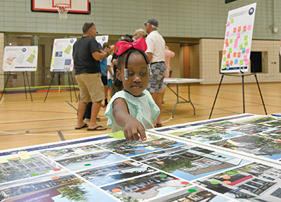
At the forums, participants were asked to place stickers on boards to indicate which goals in the current plan are still relevant, to show what sort of designs they favor in residential and commercial buildings, and to point out areas in the county that should either be developed or preserved. They were also asked to provide ideas for new goals and comment on the existing plan.
Some participants criticized the process as overly simplistic, but the goal was “to help us understand better what people felt was appropriate development,” said Ryan Bland, a senior planner with Boureaux, a Columbia-based design firm that is leading the update.
He estimated about 300 people attended the forums, which were held in Murrells Inlet, Georgetown and Choppee over three days. Some people attended more than one session, and members of the citizens group Keep It Green, which has challenged the county over land use issues on Waccamaw Neck, were at each location.
The top comments received called for the county to “maintain community character and compatible development” and “preserve natural resources,” according to a summary presented to the Planning Commission last week.
Among the current land use goals, protection of beaches and dunes received the highest number of stickers, 112, to indicate it is still relevant. Tree protection was second with 78. Limiting density and increasing housing choices topped the list of suggested goals for the update.
A third firm, Restoration 52, is helping with affordable housing, which also ranked among top concerns. Of 60 comments received on that issue “a lot of them were concerned about gentrification,” Bland said.
Petrosky said 42 percent of the county’s land, 214,529 acres, is already preserved through public and private initiatives.
“On the one hand, that’s a constraint to development,” he said. On the other, “it’s exemplary how much land has been conserved.”
The land use element needs to include goals that will help connect the open spaces, Petrosky said.
Stickers placed on maps at the forums show significant overlap. The highest concentration of green stickers indicating preservation were in the Pawleys Island-Litchfield area and Murrells Inlet. Those were also areas shown as ideal for commercial development with red stickers and for residential development with yellow stickers.
A closer look at the actual stickers showed the green dots for preservation far outnumbered the yellows and reds. Murrells Inlet only had one red and yellow sticker in a sea of greens.
“Some of those dots came with caveats,” Petrosky said.
The Parkersville area in Pawleys Island had several yellow stickers for residential development, but handwritten notes next to them called for that to be affordable housing.
The major highways running through the county were also shown as ideal for commercial development. Residential development opportunities outside of Waccamaw Neck were mostly around the city of Georgetown.
Petrosky said the land use plan also needs to consider existing infrastructure, especially water and sewer, when locating areas for future growth.
“We need to be more strategic,” he said.
The commission is due to meet with County Council on Nov. 13 to review progress on the update. Another round of public meetings will be held after Thanksgiving to get comments on a proposed draft of the plan. There will also be a virtual meeting scheduled for people who can’t attend an in-person session.