Land use
County running the numbers on residential density under proposed maps
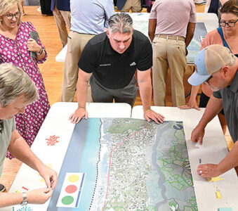
Consultants are expected to provide data on what the Waccamaw Neck will look like when it’s built out before a draft of the future land use plan comes up for discussion before Georgetown County Council this week.
The county is seven years behind schedule in adopting a 10-year update to the land use element of its comprehensive plan. It hired the Columbia-based firm Boudreaux last year to complete the process after years of false starts.
The Planning Commission last month adopted the update in a 4-3 vote before hundreds of Waccamaw Neck residents who opposed the revised plan because they didn’t think it did enough to reduce the density of future development.
The citizens group Keep It Green analyzed the future land use maps that are part of the element and estimated that the revisions could add over 5,000 homes to what the current maps envision.
The maps themselves don’t determine what can be built. That is governed by the zoning ordinance. But the county plans to revise its zoning code this year.
Ryan Bland, a senior planner with Boudreaux, told the council at a special meeting last week that he was analyzing the impacts.
Among the goals of the updated land use plan is reducing the amount of land zoned “general residential,” the zoning district that has the highest density and that allows multi-family development.
“We heard a lot about this ‘general residential’ designation,” Bland said.
The plan proposes changing over a thousand acres to another classification.
“I’m elated to hear you say that,” Council Member Bob Anderson said. “I’m anxious to see the details of what you’re doing on that 1,000 acres.”
As an example, Bland pointed to the area on the northwest corner of Highway 17 and Waverly Road in Pawleys Island. The Island Shops and Downtown Pawleys face the highway and Professional Lane to the north. Along Waverly Road, there are 21 lots zoned “general residential” or GR.
The GR zoning would allow high density development, which is defined as more than five units an acre and up to 16 units if they are efficiency apartments. But the current land use maps show those lots as medium density, between two and five units an acre.
The proposed maps change that corner to “village center,” which envisions a mix of residential and commercial uses. The residential density would be four to eight units an acre.
If the zoning ordinance is changed in accordance with the proposed designation, it would reduce the density.
Under the method used by Keep It Green, the change would increase density. If the current zoning conformed to the current land use maps, the lots on Waverly would be limited to no more than five units an acre. Under the proposed map – and any ensuing change to the zoning – the property could be developed up to eight units an acre.
Keep It Green’s calculation doesn’t consider any residential use for property shown on the future land use maps as commercial. So the proposed change to “village center” would also represent a density increase.
The county points out that the zoning ordinance currently allows up to four units an acre in the “general commercial” district or one unit for every retail space.
Bland said after the council meeting that comparing the proposed maps to the current zoning gives a more accurate picture of what could change. The current maps, now almost 17 years old, don’t account for what has actually been built since they were adopted, he explained.
Keep It Green argues that its comparison of the current and proposed maps is accurate because the county failed to bring the zoning into compliance. That is among the issues in three lawsuits brought by the group and others challenging county land use decisions.
Cindy Person, chief counsel for Keep It Green Advocacy, said she will be interested to see the consultants’ numbers.
Their own consultant recently completed a review of their earlier findings using data the county added to its geographic information system. It was data they hadn’t been able to get from the county through an open records request, Person said.
“That allowed us to verify our calculations,” she said. “These are real numbers.”
The council has moved its meeting on Tuesday from the old courthouse to the Howard Center auditorium in anticipation of a crowd. The land use element will be up for the second of three required readings.
Bland told the council last week that the broad goals were to manage growth on the Waccamaw Neck and encourage growth in the western part of the county while accounting for limited infrastructure and wetlands.
“That’s kind of baked into the land use plan,” he said.
There are also limits to the infrastructure on Waccamaw Neck, said Jake Petrosky, a community planner with Stewart, a North Carolina firm that is working with Boudreaux.
“That’s why we’re leaning more toward the growth management,” he said.
Council Member Clint Elliott asked how many areas are available for high density development.
Holly Richardson, the county planning director, said about half a dozen.
“There’s not a lot of available property to do this sort of thing,” Bland said. “In no way will Pawleys Island be inundated with high rise residential development.”
Over a series of drafts, the density limits were reduced, he added.
Council Member Stella Mercado questioned how the goal of creating walkable communities could be achieved with a 90-foot building setback along Highway 17.
“The 90-foot setback is something that honestly does inhibit walkability and connectivity,” Bland said, but acknowledged that the community wants the setback.
It’s possible that changes to the zoning ordinance could allow the setback to be reduced in some areas to create “a sense of arrival.”
Anderson pointed out that the setback wouldn’t restrict a multipurpose path.
He asked how the proposed land use plan would address stormwater issues. The plan calls for more compact designs that would reduce the amount of impervious surfaces such as rooftops and driveways, Bland said. It also calls for retaining 50 percent of the land that is currently undeveloped as open space.
“We think this provides a well grounded and balanced approach,” Bland said. “The implementation is what will be the key.”