Land use
Long-awaited flood maps take effect next month

There will be winners and losers. Property owners may not know which category they are in until the get the bill for their insurance premium or file a claim.
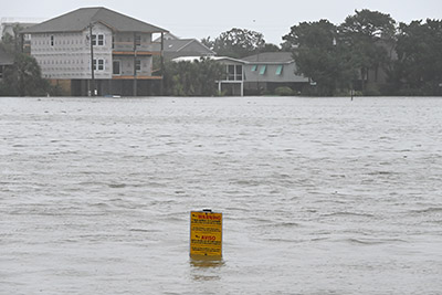
New maps from the federal government that show flood risks across Georgetown County will go into effect next month, eight years and several storms after they were first proposed.
The flood insurance rate maps are used to determine where and how high structures must be elevated to reduce flood damage. The county must approve the maps and update its flood damage prevention ordinance in order for property owners to be eligible for the National Flood Insurance Program.
“We really had no choice in this matter,” County Council Member Raymond Newton said before moving the issue forward last week. It is due for final approval this week.
Georgetown County is the last of the state’s 46 counties to get new flood maps. After they were first issued in 2015, using data collected years before that, the local maps were caught up in an appeal from Horry County and, later, delayed by the discovery of errors in a few of the 110 map panels that cover the county.
The delay has created uncertainty, particularly after Hurricane Ian last year, which coincided with the announcement of an effective date for the maps.
“We have citizens now who can’t do anything with their damaged house from the last hurricane because they’re in a substantial damage situation,” said Steven Elliott, the county’s chief building official.
That was because the ordinance requires the structures be brought into compliance when renovations or repairs exceed 50 percent of their value. Some people who were faced with compliance after Ian will be able to avoid that after the new maps take effect because they will be in a less restrictive flood zone.
That’s the case in oceanfront areas.
“Sea level, according to our experts, is going up about a foot, but the elevation to build on most of the properties is going down,” Elliott said.
One reason for the change is that the new maps, created by the Federal Emergency Management Agency, use reference data from 1988. The current maps use data from 1929.
Newton said he was concerned about the impact of compliance on low-income residents.
“It’s going to cost them much, much more than it would have last year. We’re causing the people that could least afford this, we’re putting the burden on their back,” Newton said.
Holly Richardson, the county planning director, said that could be the case in certain flood zones, known as “unnumbered A Zones,” where the flood maps don’t specify how high structures must be elevated.
“We’ve had a good bit of discussion about that,” she said. “What we would propose is to look at this as part of the budget discussion and look at a way the county could provide some assistance, especially for lower-income residents.”
The new maps pose another issue for some property owners. They include a designation for the “limit of moderate wave action,” or LiMWA. That isn’t shown on the current maps. Under the building codes used by the county, structures in A Zones must be elevated if they also fall within a LiMWA, but since that designation doesn’t appear on the maps structures can also be flood-proofed and built on the ground.
That change could have a significant impact along the Murrells Inlet waterfront, so Georgetown County plans to seek an amendment to its code from the S.C. Building Codes Council. That is scheduled for this spring, Elliott said.
If it doesn’t adopt the changes, the county could lose federal flood coverage. “That could be catastrophic,” Newton said.


