Land use
Revisions proposed to maps to cut future density
Matt Collison has only lived in Heritage Plantation for a year.
He wasn’t here for the charettes, the corridor studies, the online survey or the delays that made up Georgetown County’s efforts since 2019 to revise the land use element of its comprehensive plan.
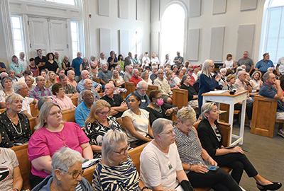
“I’m a newbie,” Collison said as he reached the podium, one of 26 speakers out of nearly 200 people who showed up for a Planning Commission hearing on the draft last week.
The county planning director, Holly Richardson, said the future land use maps and the text of the plan will reduce residential density in some areas of the Waccamaw Neck and maintain medium and low density in others.
“This takes that ‘general residential’ area and shrinks it,” she said, referring to the zoning district with the highest density. It would make over 1,000 acres medium density.
The speakers before Collison disputed that.
“There is no longer a low density category on Waccamaw Neck,” said Duane Draper, who chairs the citizens group Keep It Green.
“Density will increase across the board,” said Elaine Cooper, a Pawleys Island resident.
Collison’s question to the commission was: how many dwellings are allowed under the current land use maps and how many will be allowed under the proposed maps?
Richardson said she would find out.
The commission voted to defer action on the land use element, which is seven years past the 10-year update required by state law.
In addition, Richardson said the planning staff and consultants would review further changes to the maps that would designate some areas “rural residential” which would reflect a goal of less than one unit per acre.
Among those areas are Litchfield Country Club and the Founders Club, two of three areas that have golf courses that are not part of stand-alone “planned development” zoning districts. The proposed map changes would change those from “private recreational” to “residential.”
Many of the people who packed the meeting room said they were concerned that the change in the future land use maps would change the zoning.
Richardson said it would not.
“Adoption of the land use element doesn’t change anyone’s zoning,” she said.
The two golf courses are currently zoned “residential 10,000 square feet” like the neighborhoods that adjoin them. If they closed, no zoning change would be required to develop single-family lots that met that minimum size along with other requirements for streets, drainage and utilities, Richardson said afterward.
She told the audience, “we have received no plans, no requests, no development plans at all to rezone the golf courses.”
In Murrells Inlet, speakers said they were concerned that the areas along the Marsh Walk were designated for mixed-use rather than commercial under the proposed maps.
“High rises on the Marsh Walk,” asked Andy Hallock, a River Club resident, who added that the mixed-use designation in areas now shown as commercial would allow “thousands of high rise apartments and condos” along Highway 17.
Commission member David Roper asked if the creekfront restaurants could be torn down and rebuilt with condos on top.
Richardson said the current “general commercial” zoning allows residential uses with commercial uses in a 1:1 ratio.
She also pointed out that the county’s 35-foot building height limit is not proposed to change in the updated land use plan.
Snipe Allen, a Heritage Plantation resident, said he didn’t like the idea of mixed use.
“Today we don’t have houses mixed in with our businesses. Let’s keep it that way,” he said, adding “we are still looking for lower density.”
Sandra Bundy, a Murrells Inlet resident, served on the commission when the update first started. She said she learned that things that look good on paper don’t always turn out that way in reality and cited the comprehensive plan’s resilience element. It calls for keeping development out of the way of future disasters, but hasn’t been implemented, she said.
She reminded the commission that the comprehensive plan is a recommendation from them, not staff or County Council.
“It’s your job to tell them what you hear from the people,” Bundy said.
“The crowd should make you realize that the citizens of Waccamaw Neck are concerned,” said Peter Eisenberg, a Heritage Plantation resident.
Cindy Person, chief counsel for Keep It Green Advocacy, said she compared the proposed land use maps with the current maps and believes the new maps lay the groundwork for growth that will further alter the character of the Waccamaw Neck.
“We are positioned to become Myrtle Beach or Mount Pleasant,” she said. “The most disturbing part to me about all this is in the face of what the people say and what the proposed maps plainly show, that county officials stand before us and report that the maps support decreased density.”
Richardson said the maps can’t be viewed separately from the goals of the land use element, which include preserving 50 percent of the undeveloped land on Waccamaw Neck as open space. The county plans to begin rewriting the zoning ordinance once the plan is adopted, she noted.
“This lays the groundwork for that,” Richardson said.
Roper asked why the county couldn’t change the zoning now. “Tweak some of our zoning ordinances now so we could explain this is what we’re doing,” he suggested.
Richardson said that would be a lengthy process, but offered to draft some sample ordinances to show how that could work.
Commission member Marla Hamby agreed that was important.
“The County Council never changed the zoning to match the previous comprehensive plan, and that is why we have this outrage here tonight,” she said.