Pawleys Island
Town drainage study provides model for a wetter future

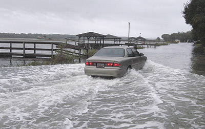
The engineers knew that Pawleys Island had a problem with flooding, otherwise they would not have been there. What surprised them, they said, was how much the water rises over the town’s streets.
“The 2023 average high tide was only about 6 inches lower than the middle of the road by the chapel,” said Rhyne Phillips, project manager for the firm SeamonWhiteside, which is creating a master drainage plan for the island. “No wind, no other forces.”
He conceded that “2023 was a bad year” for storms and that the road “might be a little higher than that.”
But a model that the firm has put together shows that over the next 50 years, even good years will be bad for flooding.
Phillips and Aaron Akin, a water resource manager, compiled data about tides, rainfall, storm surge and sea level rise in an interactive map that the town made public on Thursday after allowing officials two weeks to review it. There are 16 different scenarios that can be overlaid on a current map of the island.
A demonstration for Town Council last week showed two: an extreme high tide and a heavy rain on the north end that had standing water in the street and an extreme high tide in 50 years without rainfall that showed most of the Birds Nest section on the south end flooded.
“It’s kind of a little teaser of what’s to come,” Akin said.
What they want to do is make sure the scenarios are accurate. There are over 500 dwellings on the island. The engineers received 34 responses to a survey about drainage conditions.
They need more feedback from property owners, Phillips said. If the map shows flooding where none currently exists or shows no flooding where it does, they can examine their data.
A model that is too conservative may not lead to an effective solution. One that is too extreme may require a solution that is hard to fund, Phillips said.
The survey data will also help the town get grants to fund drainage projects, he said.
The drainage plan was funded through a state infrastructure grant. The town also got $250,000 through the state budget last year to fund projects that will help it adapt to sea level rise. The capital project sales tax passed by Georgetown County voters in November includes $2 million for drainage improvements on the island.
The sale tax revenue will help the town leverage grants that require a local match, Phillips said.
“If you have a big project that costs more than a couple of million bucks, you have to go to the federal government,” he said. Fortunately for the town, “there’s a big push in D.C. for coastal resilience.”
Once they have confirmed that their model is accurate, the engineers will start working on solutions to the flooding.
“We want to make sure we’re solving for what is actually happening,” Akin said.
Last year, SeamonWhiteside conducted an inventory of all the existing drainage infrastructure they could find. Some is 60 or 70 years old, “so there’s not a lot of documentation,” Phillips said.
They shared their findings with the state Department of Transportation, which owns the roads and drains.
“For maintenance, we need to fix it all. There really isn’t a priority,” Phillips said. “The biggest issue so far is the marsh has clogged the outfalls.”
The town has discussed a creek dredging project a couple of times in the last five years, but hasn’t settled on a focus for any work. Akin said it would be a mistake to think that deepening the creek would improve the drainage, but he said dredging around the outfalls that are currently below the marsh would provide a clear path for stormwater to drain into the creek.
Large-scale capital projects will look beyond the existing infrastructure.
“A big pipe is not necessarily going to affect tidal flooding,” Phillips said.
The flood models shows the combined effects of water flowing on and around the island.
“Because you have that dynamic tide, it can really change the way things operate,” Akin said. “There are a lot of hot spots that like to hold water, but really Pawleys has a tidal flooding problem.”
One way to protect the street from flooding would be with a berm. Asked if that would help on Myrtle Avenue near Pawleys Island Chapel, Phillips and Akin both nodded their heads. They said a berm could also prevent flooding at the North and South Causeways.
Those projects would require approval from DOT.
“It’s their right of way, so technically they can do what they want,” Phillips said, but he would hope his firm’s work could guide the design.
There is a similar structure at Folly Beach.
“It works,” Akin said. “It’s not the prettiest thing in the world.”
Other solutions could include “green infrastructure” such as a living shoreline that mimics the natural form of oyster reefs and which would be an option along the causeways.
“We don’t want to recommend a lot of bulkheads or structures in the creek,” Akin said.
After confirming the flood model and looking at the impact of solutions, the engineers will come up with cost estimates and the requirements for permitting. They will also come up with a “performance metric” to prioritize the project list.
“We don’t want to let politics get involved,” Akin said.


