Land use
Update places focus on smaller communities to preserve their character

There is no single solution to controlling future development in Georgetown County, the consultants working on an update to the land use plan said, so they divided the county into five regions.
And within those five regions there are three broad categories of land use to consider. Each of those has four to five subsets that cover conservation, residential, commercial and other uses.
“There’s not going to be a one-size-fits-all land use solution,” said Jake Petrosky, a community planner with Stewart, a North Carolina design firm that is part of the project.
The consultants gave the Planning Commission, which must create the plan, and the County Council, which must approve it, an update on progress this week. Public meetings will be held after Thanksgiving to see how the plan aligns with the public input collected at a series of meetings in September.
The land use plan is one of 10 elements of the county’s comprehensive plan, which state law requires local governments to adopt and update at least every 10 years. Georgetown County’s current land use element was adopted in 2007.
A draft vision statement for the updated plan calls for the county to be, within the next 10 years, “an exemplar of planning with infrastructure and development that sustains, protects and restores this diverse eco-system while providing opportunities for economic development and prosperity for all residents.”
“This is going to drive future land use and zoning decisions y’all make,” said Irene Tyson, planning director for Boudreaux, a Columbia design firm that is leading the update.
Council and commission members didn’t question the vision, which also cites the value and diversity of natural and cultural resources along with “quality design” that sustains them. But they did ask for guidance in implementing the vision.
Commission member Marla Hamby cited an interview that Kevin Bland, a senior planner at Boudreaux, gave when he was planning director for the city of Aiken. In it he talked about the need to update ordinances along with the comprehensive plan. Hamby asked if he still agreed with that.
“You need to review the ordinances,” Bland said, adding that it was simply good policy. “The first step is to settle on the element.”
He acknowledged after the meeting that the “general residential” zoning district is the one that most needs updating, since it allows high density development. Four lawsuits brought by residents and citizens groups in the last two years have highlighted areas in Pawleys Island where that zoning doesn’t comply with the land use plan’s designation of medium density.
Council Member Bob Anderson asked if the plan will include a timetable for updating the ordinance.
The county has asked for a recommendation about which ordinances and regulations need to be updated, said Holly Richardson, the county planning director.
One activity at September’s public meetings asked people to select their favorite designs from panels showing single-family, multi-family and commercial buildings. Some participants questioned the purpose.
Petrosky said he expects the draft land use plan that they deliver to the county by the end of the year will include a lot of talk about design.
“Design of new development is a major factor in compatibility,” he said, and public comments so far “really reinforce compatible development.”
That includes building design and site design, he added.
The county currently has design standards for commercial buildings in the Highway 17 corridor on Waccamaw Neck. Richardson said she expects the new land use plan will recommend extending those to residential buildings.
Petrosky said the concept of overlay zones could also be applied to cultural districts to ensure that the scale of new development doesn’t overwhelm existing communities.
“We want something to be integrated with the community,” he said.
Petrosky also emphasized that future growth will be restricted because land is protected or because wetlands make it unbuildable. In addition, the lack of water and, most importantly, sewer in rural areas will make them hard to develop without a major investment in infrastructure.
Council Member Everett Carolina said there is opportunity in his district south of Georgetown where existing water and sewer lines near the city could be expanded into the rural areas.
“Land is cheap,” he said.
Council Member Raymond Newton asked for more details about the availability of water and sewer, pointing out that would show where development can be expected.
Petrosky said he would refine his data, adding that “not every part of the county has access. Due to cost, we’re not going to be able to serve all of the county.”
He is also doing a “suitability analysis” to help show areas for residential development, commercial development or preservation.
Newton also asked how the 42 percent of the land area in the county that’s protected compares with other counties. “It sems to be a good bit to me,” he said.
Most coastal counties are trying to decide how much protected land is enough, Petrosky said.
Charleston County has a greenbelt program that has expanded its amount of protected land from 38 to 42 percent, he said. The goal is 50 percent.
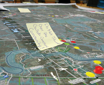
Participants at the public meetings were asked to put colored stickers on maps showing where they think land should be developed or preserved. Some of those area overlap. There were 69 stickers for commercial development, 113 for residential development and 325 for preservation.
The future land use maps that are part of the plan will be based on five “character areas”: the Waccamaw Neck; the areas around Georgetown; a northern area from Plantersville to Pleasant Hill; a southern area from Santee to Sampit; and a western area from Andrews to the Berkeley County line.
Within those will be three “place types”: Rural, corridors and gateways, and neighborhoods. Each has a subset of uses.
For rural places, it’s “conservation/agriculture” with limited residential uses; “rural residential” that is very low density; “rural village” that has a traditional community feel; and “village center” that could include business, schools and churches.
Corridor and gateway places are along major roads. They have “residential mixed use” that includes some commercial; “community mixed use” that is higher in density but also walkable; “commercial corridor” with larger retail and service uses; “employment” that is a catch-all for economic development; and the “Georgetown port,” which the county acquired this year from the state and plans to redevelop.
Neighborhoods include “conservation/open space” with land unsuited to development; “covenant community” where deed restrictions are in place; “residential” that is low density; and “commercial” for small-scale retail and service uses.
Bland said those categories aren’t necessarily complete. That’s something the consultants want comment on.
“Is there something missing?” he asked. “Let us know.”


